


A Very, Very Distilled (Pre)History of Every Continent and Supercontinent
By someone who is not a scientist, just a nerd.

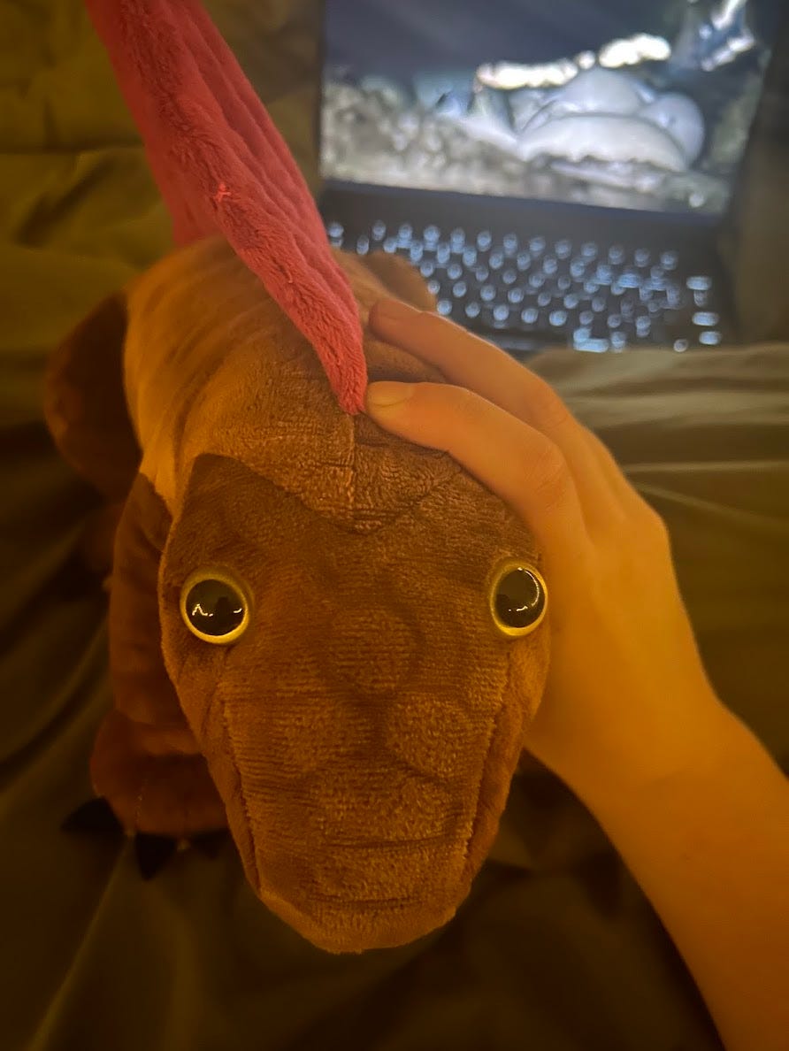
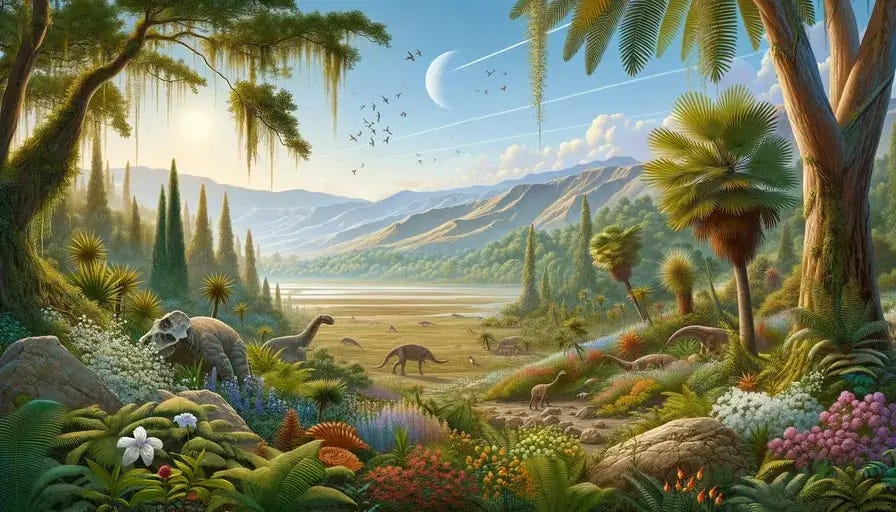
I’ve recently been thinking about supercontinents and continents. One of the many reasons why: Smithsonian’s “Where Were You Then” map. Another reason is the stuffed dimetrodon I have recently purchased, who is my best friend in the world (her name is Mia). A third reason is that I began rewatching my childhood favorite documentary, Walking With Beasts (a classic). So I figured I would assemble some of the lore that I’ve spent the last ten years infodumping about to all of my friends and loved ones.
I also want to give a big thank you to Half Baked Oyster for encouraging and enabling this. Thanks Angel!
Disclaimer that I do not study paleontology professionally — I have just been very into prehistoric plate tectonics since I was six years old, and have read *a bunch* about these over the years. I primarily sourced this via “reading Wikipedia and checking the Wiki-cited sources”, as paleogeographic Wikipedia is known for being at least fairly accurate. I’ve noted several areas of controversy as we go further back in time!

The earth may have had continents — of a type — since before life formed. Earth is approximately 4.5 billion years old; water is about 4.4 billion years old; and the first larger pieces of continental crust appeared around 4 billion years ago. Life is approximately 3.5 billion years old.
Reconstructions of older continents — pre Phanerozoic, or the current eon, which started in 538 Ma — are notoriously difficult to complete. There are several theories as to what the first couple of continental assemblages may have looked like, which you can find a list of here. (As far as I’m aware, there is not a scientific consensus on the listed.) But it’s generally agreed the earth evolved into a few supercontinents in the Archaean period:

Columbia, or Nuna, probably existed sometime from 1.8 — 1.3 billion years ago. Evidence for this supercontinent comes from an array of orogenic zones from this age in the modern day.
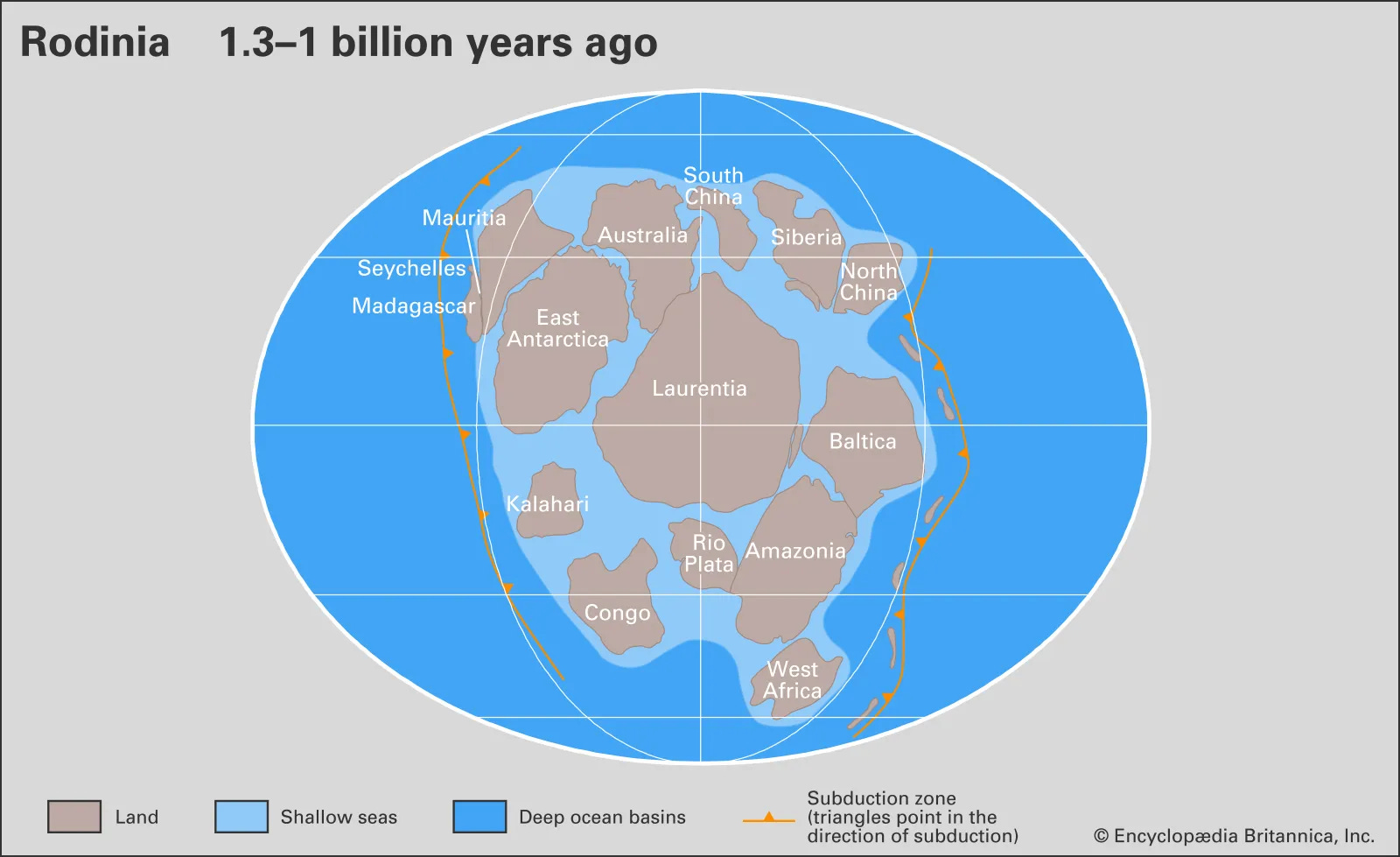
From approximately 1.2 billion years ago to sometime 900-600 million years ago (Ma), the continents merged to form new supercontinent Rodinia centered around the equator. During the existence of Rodinia, there were four periods of so-called ‘Snowball Earth’, each lasting about 10 million years, when Earth is thought to have been entirely covered with ice.

There is one final supercontinent worth mentioning here — the hypothetical Pannotia, which would have existed around 600 — 500 Ma. The existence of this supercontinent is extremely controversial. It’s often raised as the third iteration of the so-called supercontinent cycle, a hypothetical dynamic wherein the world rotates into supercontinents approximately every 400 million years. Pannotia believers essentially believe Laurentia did not start migrating away from Gondwana until a brief period of merging; doubters think Laurentia had already started moving north and opened up the Iapetus Ocean.

The Paleozoic
As the Paleozoic period began and the Precambrian ended, Laurentia — a large continental craton that now forms most of North America — broke off and moved north to the equator. This left behind a larger continent known as Gondwana, which merged South America, Africa, Arabia, India, Antarctica, and Australia.


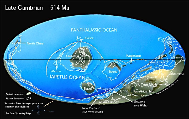
Cambrian (alt map) (538 Ma — 487 Ma) — The southern hemisphere was primarily dominated by the south-drifted Gondwana (which as you may be observing, was absolutely massive) with Laurentia near the equator. The two were separated by the Iapetus ocean. The smaller continent of Baltica (modern-day eastern Europe) lay just north of Gondwana, with the two separated by the Ran ocean and with Siberia, which would remain a completely independent continent until the Carboniferous, nearby. The Panthalassic Ocean surrounded all of these countries the north. There is some disagreement about the state of Indochina and South China, which were connected, and North China; each may have been connected to Gondwana or have rifted away.
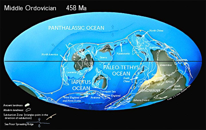
Ordovician (alt map) (487 Ma — 443 Ma) = Gondwana had at this point migrated. Baltica and Siberia migrated slightly further north and were clustered near Laurentia — a cluster divided from Gondwana by the Paleo-Tethys. (Remember this name, because the Tethys won’t leave our globe for several hundred million years.) The Appalachian mountains also grew in height significantly during this period, when two volcanic island arcs crashed into Laurentia! Very awesome. This period also saw the rifting of Avalonia (modern day Britain, Ireland, and Newfoundland) from Gondwana — as it drifted towards Baltica, the Rheic ocean formed behind it and the Iapetus shrunk. The late Ordovician was also, notably, a bit of an ice age, and ice covered Gondwana.
Really cool fun fact: This period was followed by the Ordovician–Silurian extinction events. During the so-called Ordovician meteor event, 100 times as many meteorites struck the Earth per year compared to today — which some geologists theorize is due to a ring system that formed around Earth at the time. Earth’s rings were attacking us! Is it bad that I think this is incredible?
Silurian (alt map) (443 Ma — 420 Ma) — Gondwana continued to cover the south and east, with the Panthalassic covering most of the northern half of the globe. Near the equator, however, Baltica, Avalonia, and Laurentia united to form a new continent — Euramerica, or Laurussia, aka the “Old Red Sandstone continent”. Now we have most of Western Europe partying! (This collision formed, hilariously, more of the Appalachians — and the Caledonian mountains, in Britan and Scandinavia.) Euramerica and Gondwana were separated by the Iapetus Ocean on the west; the Rheic Ocean; and PaleoTethys to the east. Siberia continued its drift north. The briefly-extant Ural Ocean split Siberia from Baltica (wonder what mountains that will create when it closes!), and the briefly-extant Proto-Tethys split Siberia from North China (to the north of Gondwana).
Devonian (alt map) (420 Ma — 359 Ma) = Gondwana drifted back southeast, and Laurussia, also south of the equator, began to rotate counterclockwise into its current alignment. Heat led to the first-ever forest growth and high sea levels. In the Late Devonian, the Iapetus disappeared into a merge with the Rheic as Laurentia drifted south. Indochina-South China made their split from Gondwana, as did various other large chunks of Asia. Does anyone else find it funny that the largest world continent was mostly just little pieces despite almost every other continent being mostly intact?

Carboniferous (Pennsylvanian) (alt map) (359 Ma — 299 Ma) = The Rheic ocean, which was still splitting Gondwana and Euramerica, slowly closed — Pangea incoming! The northward drift of South China and North China created a larger and more coherently split off Paleotethys. The south pole was covered by ice, lowering sea levels — meaning more land. This period is known for really large bugs.
The Carboniferous is, as you might have noticed, very long, so it’s often split into two periods — the Mississippian, and the Pennsylvanian.
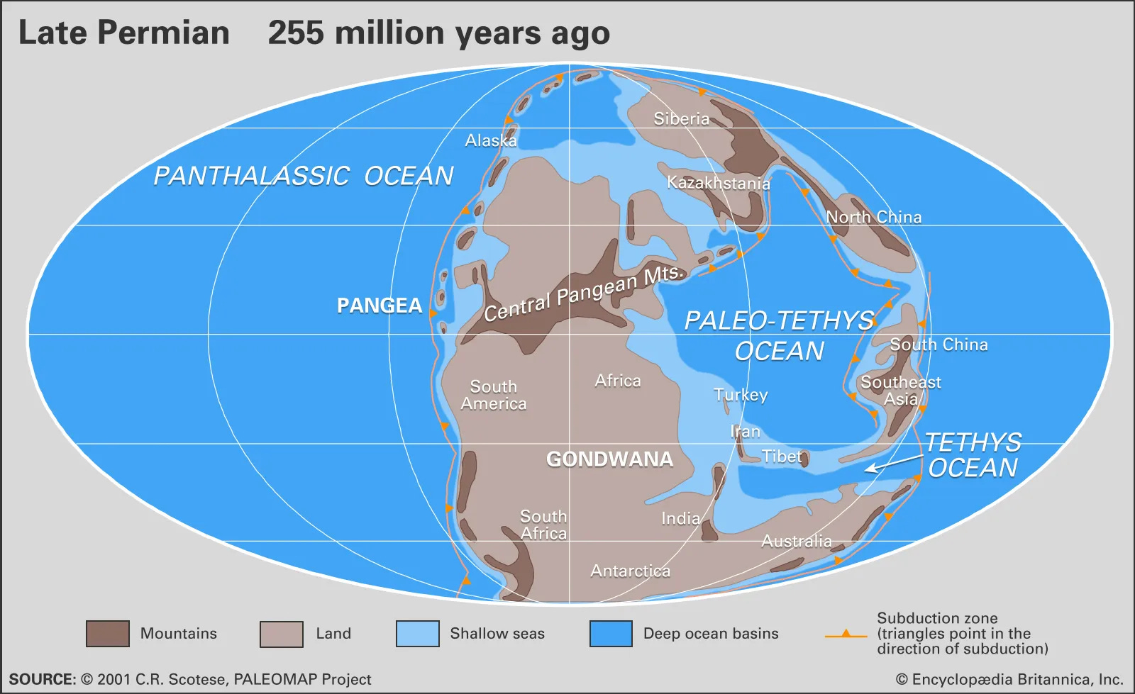
Permian (alt map) (299 Ma — 252 Ma) — The moment you’ve all been waiting for: It’s Pangaea. Due to this density, the world was covered by deserts — and the ice began to melt. A string of microcontinents known as Cimmeria (the modern-day Middle East) migrated north from Eastern Gondwana, arguably creating a passage in the PaleoTethys: the Neo-Tethys. (Again, when I say they can’t stop using this term, I am so serious, this is only the third of four Tethys oceans.)
You may be noting that a long band of mountains known as the Central Pangean Mountains formed during this era. These mountains were the size of the modern-day Himalayas, but most of them are nowhere near that height in the present day. In the modern day, pieces of these mountains are scattered around the globe, and I do mean that —

The Permian period ended in the Permian-Triassic extinction event, the largest extinction Earth has ever known, wiping out a staggering 70% of terrestrial vertebrates and 81% of marine species — including the Synapsids, a reptilian precursor to mammals. The extinction was probably caused by the explosion of the Siberian Traps (not even located in Pangaea! Sad!) leading to widespread climate change. If I think too hard about this extinction I might get legitimately sad.
The Mesozoic

Triassic (alt map) (252 Ma — 201 Ma) — The Ural Ocean between Siberia and Baltica finished closing in order to form the — plot twist — Ural Mountains. North China and South China continued to form a barrier between East Panthalassic and the Tethys oceans, but also continued their drift northward.
This era ended in the Triassic–Jurassic extinction event, caused by the initial eruption of the Central Atlantic Magmatic Province — which also initiated the creation of the Atlantic Ocean. A volcanic province caused an extinction, and simultaneously broke a supercontinent in two.
At the same time, the northern half of Pangaea — now known as Laurausia due to its newly-added Asian provinces — and the lower half, still known as Gondwana and containing essentially identical land, began to split from one another. In just one period of fifty million years, the earth went from one supercontinent to several.

Jurassic (late half) (alt map) (201 Ma — 143 Ma) — The breakup of the contents continued. The Middle East (remember Cimmeria earlier?) connected with northern Laurasia, making the Tethys massive and closing the PaleoTethys. A marine transgression in Europe transformed most of it into a collection of islands. And North America and South America split, forming the Caribbean seaway.
During this period, the plate composition of the Panthalassic began to shift pretty drastically. In the middle of the vast oceanic crust — previously split between three plates, the Izanagi, Farallon, and Phoenix — the new Pacific plate began to form. Around the end of the Cretaceous, these old plates were primarily replaced by the Pacific.
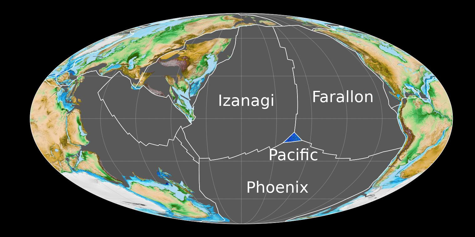
The Izanagi plate is no longer extant. The Pheonix plate and the Farallon plate, however, each have left behind microplates. The Pheonix left behind just one, under Drake’s Passage. The Farallon has left behind several more, including the Juan de Fuca, Rivera, Cocos, and Nazca — part of the reason the west coast of the Americas is so earthquake-prone.
The boundary between the Jurassic and Cretaceous is the only one between periods not marked by some specific event. Very cool.
Cretaceous (alt map) (143 Ma — 66 Ma) — Gondwana began a split, with only Australia and Antarctica remaining attached. India began to move north, and Asia and Alaska connected. During this period, sea levels rose drastically, opening a vast North American sea and a vast sea known as the Turgai Strait near the modern-day Ural river.
If you’re noticing that the vast North American sea formed in a similar position to the Rockies, that’s not quite a coincidence — the sea is essentially seen as a “buckling” of the crust just before the forming of these mountains. How did the Rocky Mountains get formed, then, in the middle of a stable plate? The answer is actually fairly confusing — but it does involve the dying Farallon plate. Of course.
The Hawaiian island chain also began to form in this era — but not to the South. The first islands in the Hawaiian–Emperor seamount chain are actually near the Aluetians. The Pacific plate was drifting primarily north for millions of years before beginning its northwestward drift.
Cenozoic
The Cenozoic is made up of three periods, each of which are subdivided further — and the last of which is the modern-day Quarternary.
Paleogene (Resources) (66 Ma — 23 Ma) — The age of mammals! This era is split into the Paleocene, Eocene, and Oligocene. During this period, Australia and South America rifted from Antarctica, cementing the final breakup of Gondwana. Perhaps more notably, the African, Arabian, and Indian plates all moved north and collided with the Eurasian plate — creating the Alps, Carpathians, Zagros, Caucasus, and Himalayan Mountains. The hard collision of India and Eurasia occurred around 35 Ma; the collision would’ve begun around 50 Ma.
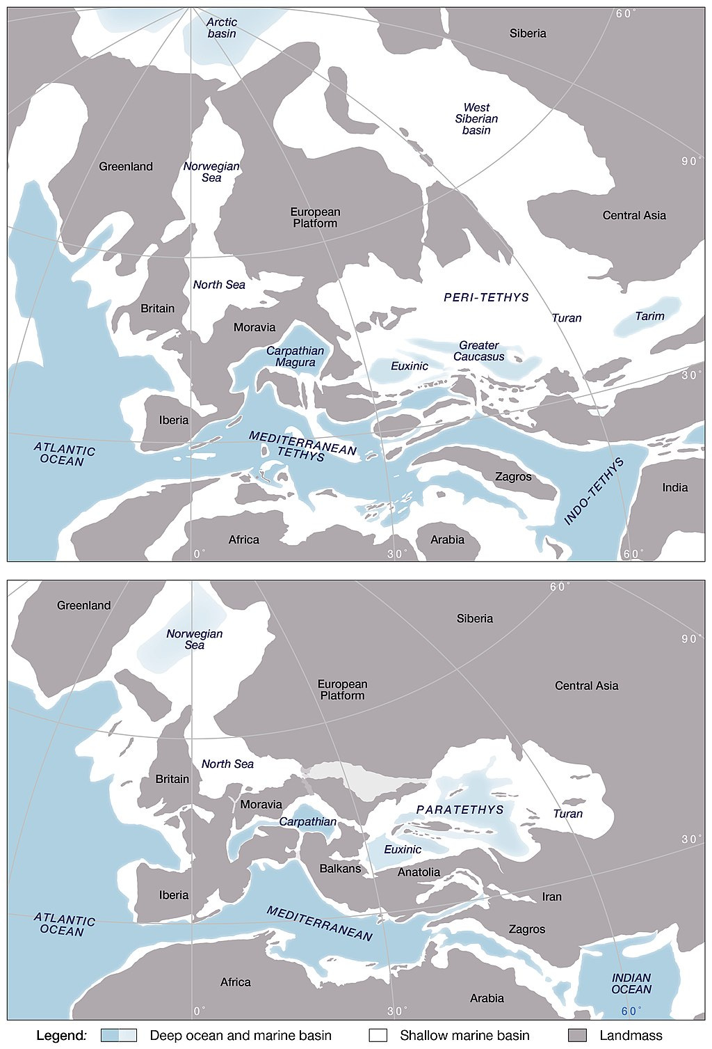
The NeoTethys briefly split into several seas — the Indo-Tethys, Mediterranean Tethys, and inland Peratethys, with the southern Tethys covered by mangroves — before the passage between the Indian Ocean and Mediterranean Sea closed. This ultimately left behind a sea called the Paratethys, which is extremely cool and will be detailed a paragraph down.
Right as the Paleocene ended (56 Ma), the world saw a minor extinction due to global warming. Another extinction ended the Eocene, this one caused in part by continental drift — changing currents due to new continental boundaries led to global droughts. The new freeze of the ice caps and multiple meteor strikes also contributed.
Neogene (23 Ma — 3 Ma) — This era was divided into Miocene and Pliocene. Continents were essentially as they are now.
The Panamanian isthmus formed between North and South America around 3 Ma, leading South American and North American animals to meet for the first time since the Cretaceous — and creating the Gulf Stream. Yay! The Messinian Event between 6 Ma and 5 Ma saw the Mediterranean Sea briefly dried up due to the closer of the Gibraltar strait.
Asia remained flooded by the Paratethys until around 5 Ma — the largest lake of all time. The Paratethys contained more than 1.8 million cubic kms of, more than ten times the volume of all current lakes — salt and freshwater — combined. The lake housed miniature whales and seals alike. Ever wonder why there are several inland seas in modern-day Western Asia and Eastern Europe? The Black Sea, Caspian Sea, Aral Sea, and others are remnants of the Paratethys.
And with that… we’re in the present day! If you made it to the end of this extremely long post, please leave me a comment and tell me your favorite continent name and/or new thing you’ve learned from this post. Have a great day, y’all <3
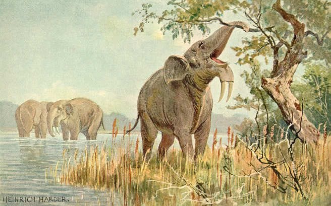
Elleeeee, this is so good. Thank you so much for writing it. I learned so much. It's so funny how paleontology uses such interesting sounding names for oceans and continents and eras - but they all fit so well. When I was younger I would spend hours staring at prehistoric animals and being like omg - which is one reason why I became an environmental science major (not that we learned about that at all...). The Deinotherium is pretty awesome.
Also -- this post, and generally when learning about earth history really puts in perspective how relatively new humans are and how fleeting our current world (the continents are bound to move sometime) is. Pale blue dot type of thinking, which I like.